Aller au contenu principal
Rechercher
Search
Search
Search
View this page in:
English
Español
Fil d'Ariane
Accueil
Search
Displaying 201 - 209 of 209
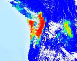
Washington Atmospheric Rivers 2025
Disaster Type
Landslides
Floods
décembre 7, 2025
U.S. Winter Storm Jan 2026
Disaster Type
Severe Weather
janvier 23, 2026
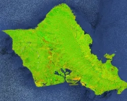
Hawaii Floods March 2026
Disaster Type
Floods
mars 10, 2026
Disasters
Study Reveals Heat Risk to Elderly in 85% of Austin Single-Family Homes During Power Outages
By
Seph Allen, NASA Disasters Program
avril 13, 2026
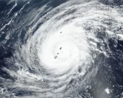
Typhoon Sinlaku April 2026
Disaster Type
Hurricanes & Cyclones
avril 15, 2026
Disasters
NASA Tracked Sinlaku's Rainfall from Space When Ground Radars Went Dark
By
Jacob Reed, NASA Disasters Program
avril 24, 2026
NASA Aids in Kansas Fire Response
Topic
Disasters
Resource Type
Print Materials
NASA Disasters Kansas Fires One-pager
DRCS CONOPS
Topic
Disasters
Resource Type
Publications
DRCS CONOPs 6-11-26_0.pdf
Working With the DRCS
Topic
Disasters
Resource Type
Print Materials
DRCS_Brochure_Web508_SinglePage_June2026.pdf
Pagination
Première page
« First
Page précédente
‹ Previous
…
Page
13
Page
14
Page
15
Page
16
Page
17
Page
18
Page
19
Page
20
Page courante
21