Hurricane Matthew dropped a lot of rain, caused flooding and deaths in the state of North Carolina. Flooding is still widespread in North Carolina. Some rivers in North Carolina such as the Tar and the Neuse Rivers were still rising on Oct. 12.
At NASA's Goddard Space Flight Center in Greenbelt, Maryland a rainfall analysis was accomplished using data from NASA's Integrated Multi-satellitE Retrievals for GPM (IMERG). The GPM or Global Precipitation Measurement mission is a joint mission between NASA and the Japanese space agency JAXA. The Integrated Multi-satellitE Retrievals for GPM (IMERG) is a unified U.S. algorithm that provides a multi-satellite precipitation product. IMERG is run twice in near-real time with the “Early” multi-satellite product being created at about 4 hours after observation time and a “Late” multi-satellite product provided at about 12 hours after observation time.
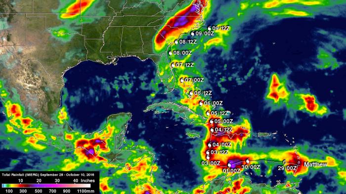
This animation shows the amount of rainfall dropped by Hurricane Matthew over the life and track of the storm/ IMERG real time data covering the period from Sept. 28 through Oct. 10, 2016 show rainfall from Hurricane Matthew before and after its interaction with a frontal boundary. Matthew caused extreme rainfall in North Carolina resulting in over 20 inches (508 mm) of rain.
Credits: NASA/JAXA, Hal Pierce
Hurricane Matthew’s interaction with a frontal boundary caused extreme rainfall in North Carolina resulting in over 20 inches (508 mm) of rain being reported in North Carolina. The area was already saturated before Hurricane Matthew arrived. Heavy rainfall from a slow moving low and frontal system moved through during the last week of September. Maximum rainfall total estimates for the real-time IMERG product have been adjusted to reflect observed values.
On Wednesday, Oct. 12 the National Weather Service (NWS) in Wilmington, North Carolina (NC) reported "All major area rivers will remain above flood stage throughout this upcoming week. At 10:59 a.m. EDT on Oct. 12, the North Carolina Department of Transportation reported numerous flooded roads persisting across much the coastal plain of North Carolina. This being the result of heavy rainfall totaling 5 to 12 inches across the region in the last 36 hours. Many roads are impassable, barricaded or washed away. Some neighborhoods are cut off. Swamps, creeks and rivers are still rising flooding even more areas and slowing the recession of high water. People in the warned area should not travel and be prepared for widespread flooding of a magnitude not seen in many years. If asked to evacuate please do so.
In this animation Hurricane Matthew travels up the east coast from Florida to the Carolinas. On October 8, 2016 Matthew (still a category 2 hurricane) dumps massive amounts of rain throughout the southeast dousing North and South Carolina. GPM then flies over the area revealing precipitation rates on the ground. As we zoom in closer, GPM's DPR sensor reveals a curtain of 3D rain rates within the massive weather system. To download: http://svs.gsfc.nasa.gov/cgi-bin/details.cgi?aid=4512Credits: NASA SVS
Further south, a Flood Warning has been extended for the following rivers: Cape Fear at Elizabethtown affecting Bladen County NC; Cape Fear at Lock and Dam 1 affecting Bladen County NC; Black Creek at Quinby affecting Darlington and Florence Counties South Carolina (SC); Lynches at Effingham affecting Florence County SC.
In addition, a Flood Warning continues for the following rivers: Cape Fear at William O. Huske Lock and Dam 3 affecting Bladen County NC; Northeast Cape Fear near Burgaw affecting Pender County NC; Lumber Near Lumberton affecting Robeson County NC; Little Pee Dee at Galivants Ferry affecting Dillon, Horry and Marion Counties, SC; Waccamaw at Conway affecting Horry County SC; Great Pee Dee at Pee Dee affecting Marion and Florence Counties SC; and Black at Kingstree affecting Williamsburg County SC.
For updated River Forecasts from the NWS, visit: http://water.weather.gov/ahps2/forecasts.php?wfo=ilm
Instrument / Model: IMERG


