Imagen

Start Date: July 4, 2025
Type: Floods
Region: Texas, North America
View maps and data on the NASA Disasters Mapping Portal
NASA’s Disasters Response Coordination System (DRCS) continues to support emergency management agencies responding to the Texas floods. Last week, NASA conducted a series of flights over the Guadalupe, San Gabriel, and Colorado river basins, and the DRCS team has since shared a range of aerial and satellite-based data products to assist partners in assessing flood impacts and guiding response and recovery efforts. These include WB-57 DyNAMITE high-resolution imagery to support search and rescue efforts and response planning, UAVSAR flood classification maps to identify open water flooding and inundation under the tree canopy, Planet NDVI change analysis maps to show areas of potentially impacted vegetation, and more. Maps and data are being shared on the NASA Disasters Mapping Portal as they are produced.
Download a one-pager with information on the flights and NASA’s response efforts.

The above map shows imagery collected from the DyNAMITE instrument aboard NASA’s WB-57 aircraft. These data were collected during flights over the Guadlupe River Basin on July 8, 2025, and the San Gabriel River on July 10, 2025. The flights were coordinated by NASA’s Disasters Program and NASA’s Airborne Sciences Program and flew out of NASA’s Johnson Space Center in Houston, TX. The imagery is much higher spatial resolution than typical satellite imagery, enabling detailed analysis of ground conditions in the wake of the floods. Responders in Texas are using it to aid search and rescue operations and to provide situational awareness for response and recovery planning.

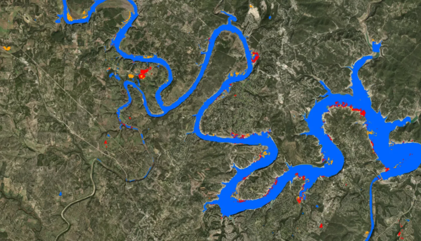
This map shows classifications that help identify flooded urban areas, croplands, vegetation, and open water using UAVSAR data collected during flights on July 9, 2025. The UAVSAR flights were coordinated by NASA’s Disasters Program, NASA’s Airborne Sciences Program, and NASA’s Jet Propulsion Laboratory, and flew out of NASA’s Armstrong Flight Research Center at Edwards Air Force Base in California.
The colored areas in the image show likely detected flooding, with the color indicating the type of landcover which was flooded. Non-flooded areas are transparent. In urban areas, the flood classification may include false positives due to limitations of the radar sensor, which is the case in Austin, TX. These data were collected several days after the flash floods, so previously flooded areas are also not shown.
As response and recovery efforts in Texas continue, the NASA Disasters Program is coordinating with NASA’s Airborne Sciences Program to conduct a series of flights to collect high resolution optical imagery and radar measurements of the impacted regions. NASA is deploying two aircraft—the WB-57 with DyNAMITE sensor from NASA’s Johnson Space Center, and the UAVSAR-equipped Gulfstream III from NASA’s Armstrong Flight Research Center. The NASA Disasters Response Coordination System will share data from these flights directly with FEMA, state agencies, and humanitarian partners to guide search and rescue, damage assessment, and resource allocation.
Learn more: NASA Aircraft, Sensor Technology, Aid in Texas Flood Recovery Efforts
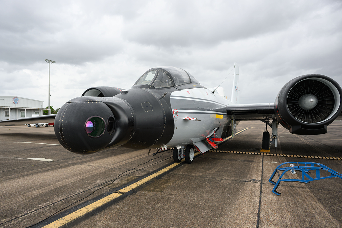
The high-altitude WB-57 aircraft departed July 8, 2025, from Ellington Field in Houston, Texas, headed to the Texas Hill Country. The aircraft used the DyNAMITE (Day/Night Airborne Motion Imager for Terrestrial Environments) sensor system to take video mosaics of the area to assist with the emergency response effort.
Photo Credit: NASA/Morgan Gridley
Beginning on July 4, torrential rainfall fueled by the remnants of Tropical Storm Barry triggered catastrophic flooding across Texas Hill Country. The Guadalupe River rose with alarming speed, inundating communities throughout Kerr County. The floods have caused significant loss of life, widespread property damage, and power outages, while prompting hundreds of emergency rescues. Forecasters expect additional rainfall in the coming days, increasing the risk of further flooding.

1-day precipitation totals from NASA’s IMERG multi-satellite precipitation product show heavy rainfall over central Texas on July 4, 2025. Credit: NASA Worldview, Jacob Reed (NASA GSFC)
To support the ongoing disaster response, the NASA Disasters Response Coordination System (DRCS) has been activated. NASA is working closely with the Texas Department of Emergency Management (TDEM), FEMA Region 6, and the humanitarian organization Save the Children to deliver critical data and decision-support tools. The DRCS team are working to produce flood extent maps generated from synthetic aperture radar (SAR) and optical satellite imagery, along with assessments of affected infrastructure. The DRCS are also sharing near real-time NASA IMERG satellite precipitation data and NASA LHASA landslide maps of the region to help assess areas of potential landslide risk. Maps and data products are being shared on the NASA Disasters Mapping Portal as they become available.
UAVSAR data collected from the July 9 NASA flights was used to classify the likely areas of flooded developed areas (red), flooded croplands (orange), and areas of open water (blue) around Lake Travis, Texas. Credit: NASA