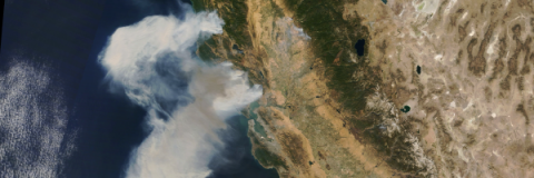
Fast burning wildfires broke out this week in California, forcing thousands to evacuate. So far, the fire has consumed thousands of acres of land and destroyed property.
Remote sensing can be used to monitor wildfires, classify land in its path, track smoke and ash, and monitor post-burn scars.
Related ARSET Resources
These trainings can help you learn about applying remote sensing for wildfires:
Level 1
Introduction to Remote Sensing for Wildfire Applications
5 hours
Level 2
Application of Satellite Remote Sensing Data for Fire & Smoke Monitoring
Materials Only
Level 1
NASA Earth Science Data for Wildland Fire Decision Making
Some Materials Available
Relevant Tools with Case Studies
These tools are helpful for monitoring and tracking fires, and have been covered in ARSET trainings:
- Fire Information for Resource Management System (FIRMS)
- Provides data for near real-time active fire locations and historical data. Demonstration in Session Two of Introduction to Remote Sensing for Wildfire Applications
- Firecast (Tool by Conservation International)
- Covers active fires, fire risk conditions, annual fire season severity forecasts, and forest monitoring. Demonstration in Session Five of Introduction to Remote Sensing for Conservation Management
- LANDFIRE
- A joint program between wildland fire management programs of the USDA Forest Service and US Department of Interior. It provides consistent, comprehensive, geospatial data for vegetation, wildland fuel, and fire regimes in the U.S. including data and reports, videos, tutorials, and decision-making tools. Slides 37-40 in Session Two of Introduction to Remote Sensing for Wildfire Applications.


