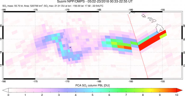
May 22nd 2018:
The Ozone Mapping Profiling Suite (OMPS) Hyperspectral UV instrument onboard the Suomi NPP (SNPP) satellite observed large extent of the volcanic SO2 clouds emitted from Kilauea eruptions on May 21-22 on Hawai'i Big island. The estimated SO2 emission rate is still elevated, at ~10-30,000 tons/day (2-6 times the long-term average flux for Kilauea)
The SNPP orbit was not well-placed so pixels near the volcano are large. The SO2 life-time is longer in the free-troposphere than near the volcano, so OMPS tracks SO2 plume ~2000 km downwind of Hawai’i. OMPS SO2 measurements help validate volcanic cloud dispersion and aerosol/chemistry models.
May 16th 2018:
Total column amount of volcanic sulfur dioxide (SO2) measured by Ozone Mapping Profiling Suite (OMPS) hyperspectal Ultraviolet (UV) spectrometer on board NASA-NOAA Suomi-NPP weather satellite from Kilauea volcanic eruption on May 16 2018, overlayed on VIIRS RGB data.
Such satellite SO2 maps show full geographical extent of airborne volcanic clouds, which is needed to confirm ash plume dispersion forecasts for aviation avoidance and volcanic fog forecasts. If the SO2 plume height is known, the column amounts could be converted into SO2 surface concentration maps for estimating hazardous health and environmental impacts.
May 15th 2018:
Total column amount of volcanic sulfur dioxide (SO2) measured by Ozone Mapping Profiling Suite (OMPS) hyperspectal Ultraviolet (UV) spectrometer on board NASA-NOAA Suomi-NPP weather satellite from Kilauea volcanic eruption on May 15 2018. Red color shows highest SO2 column amounts exceeding about 10 Dobson Units (DU). 1 DU = 2.69*10^16 molecules SO2 per cm^2.


