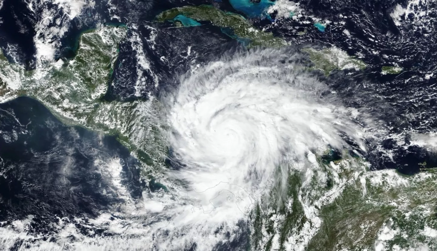
With up to 155 mph winds, Hurricane Iota smashed record books on Nov. 16 as the strongest hurricane ever recorded to make landfall in Nicaragua. Iota reached Category 5 strength before making landfall as a Category 4 hurricane near the town of Haulover, Nicaragua. Iota is advancing in roughly the same area along the northeastern coast of Nicaragua, where hurricane Eta set the previous record for strongest November storm just two weeks ago. Eta was a Category 4 storm with 140 mph winds when it landed in Nicaragua on Nov. 3 before ripping a wide path of destruction through Honduras and Guatemala.
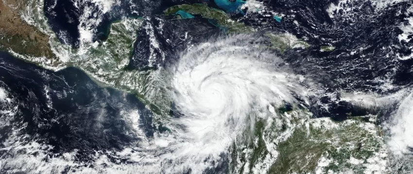
Iota has already earned an ominous place in history as the thirtieth named storm, thirteenth hurricane, sixth major hurricane, and first Category 5 hurricane to form in the already record-breaking 2020 Atlantic hurricane season.
Iota’s strength is practically unheard of this late in the hurricane season. Officials are predicting isolated totals of up to 30 inches of rain to arrive with the storm. The National Hurricane Center predicts river and flash flooding, along with dangerous storm surge that is likely to bring water levels up by as much as five to 10 feet. Central American officials are particularly concerned about flooding, mudslides, and potential impacts to the dam and systems across portions of Central America that may be exacerbated by Eta’s recent charge through the region.
Assessing Landslide and Flood Risk
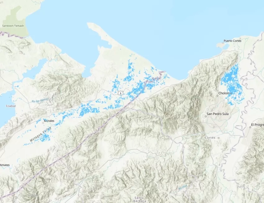
The NASA Earth Applied Sciences Disasters Program has activated in support of the cascading events of Eta and Iota. The program has been working to determine what resources and capabilities may be available to aid response and recovery and is responding to requests from multiple organizations for assistance in determining the extent of flooding, including the extent at the peak of the flooding, the risk of landslides, mapped locations of landslides, and damage mapping. These products are shared directly with local disaster management agencies, and many are shared on the NASA Disasters Mapping Portal.
The Disasters Program is working to provide information to Guatemala’s National Coordinator for Disaster Reduction (CONRED) to support response efforts in that country and is collaborating with the Coordination Center for Disaster Prevention in Central America (CEPREDENAC) to aid stakeholders in the local governments of Nicaragua, Honduras and Guatemala, El Salvador, Belize, Costa Rica, and Panama. Together they are looking to address topics such as the extent of regional flooding, the time of the next useful satellite overpasses, situational awareness for potential landslides, and more. The Program’s work with these agencies is facilitated in part by its leadership role in AmeriGEO, an organization that promotes collaboration and coordination for risk reduction in the Americas.
The Program is also working with U.S. Southern Command (SOUTHCOM) to provide situational awareness for potential emergency humanitarian assistance and aid disaster relief planning for multiple agencies.
The Program is also working with NASA SERVIR, who have provided assistance with situational awareness through their expertise in the region, and shared tools for identifying expected flood locations and preliminary flood mapping extents using Sentinel 1 imagery. The Program has also shared agricultural impact information from NASA Harvest with stakeholders in Central America.
Relevant Tools and Products:
- NASA Disasters Mapping Portal is an Esri ArcGIS-based web interface for viewing and analyzing the latest near-real-time products and disaster response datasets.
- The Pacific Disaster Center integrates NASA flood and landslide models and maps into the DisasterAWARE application, a global early warning and decision support system that translates data into actionable information to improve situational awareness, disaster response and recovery of at-risk communities. DisasterAWARE is integrated into SOUTHCOM’s toolkit to respond to Hurricane Iota.
- The Landslide Hazard Assessment for Situational Awareness (LHASA) model has being used to provide situational awareness of the landslides. NASA Disasters Program has been creating products to support decision making of the Center American authorities. These products are available on the NASA Disasters Mapping Portal.
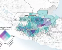
- NASA Disasters Program’s GIS team has created a web app that is now on the portal with Planet imagery over the community of Queja, Guatemala, a community affected by a major landslide due to Hurricane Eta. The web app features a slider tool showing pre- and post- event True Color and False Color RGB’s utilizing Planet data to easily compare conditions before and after the landslide. The SALaD system, developed by the Goddard team, mapped landslides over the area. This system is also included in the web app and correlates with the Planet data. The app is ready for distribution to the stakeholders and does not require a download. SALaD products for Eta for Honduras and Guatemala are also up on the portal and available for distribution and download.
- GEOGLoWS ECMWF Streamflow Hydroviewer has been actively used by stakeholders as a tool to make decisions on possible flooding. (Credit: GEOGLoWS/NASA SERVIR)
Related Applied Research:
- Advancing Access to Global Flood Modeling and Alerting
- Development of Predictive Models to Improve Landslide Disaster Risk Reduction and Response
- Integrating SAR Data for Improved Resiliencies and Response to Weather-Related Disasters
- Global Rapid Damage Mapping System with Spaceborne SAR Data
- Global Rapid Flood Mapping
- Global Systems for Local Flood Prediction and Impact
This research involves experimental products that may be used as guidance to identify areas of potential flood or landslide risk but may not indicate the actual presence of floods and landslides.
Related Impact